. . . I've been told that I write novels for email messages. Perhaps this is the way to go. I'll try to make each entry, or Gemstone, a "precious" one. On mediocre days, all I might be able to produce is a "semi-precious" entry. In any case, an entry might be a "neat" Gemstone--something that is uniquely mine.

Showing posts with label volcanoes. Show all posts

Saturday, November 12, 2011

El Malpais National Monument

For the last leg of our weekend road trip we drove down Hwy 117 on the eastern rim of "the badlands" which make up the El Malpais lava flow where it meets the sandstone bluffs.  The largest evidence of past volcanic action in New Mexico lies in El Malpais National Monument. Most of the area can be viewed by car with some small trails. The lava extends an area of 60 by 35 miles.

The El Malpais lava beds were produced from eruptions of several volcanoes up until about 800 years ago. There are numerous cinder cones and small craters found within the monument. The lava flow consists of large, blocky flows called aa to small ripples at the edges of the lava flow called pahoehoe. The rock is very brittle and sharp. The top layer is black with the lighter reddish gray colors underneath due to longer cooling time and less exposure. There are lava tubes and caves all along the monument.

View of the sandstone bluffs with the lava flows 400 feet below
Sign at the Sandstone Bluffs Overlook

The lava is bordered on the east side by a long sandstone cliff structure up to 400 feet high. We stopped at the Sandstone Bluffs Overlook to view the lava beds below. After driving a bit farther down the road, we stopped to see the La Ventana Natural Arch, the largest in New Mexico. It formed in a bend in the sandstone cliffs. The arch was eroded from sandstone dating back to the age of dinosaurs when the area was an inland sea.
La Ventana Natural Arch
You might be wondering how our chauffer did on the drive: very well. He clocked about 10 hours of driving on this trip. He still has a lot of hours left to go before his permit expires so I guess that means we'll have to go on more road trips. This weekend was a good one. I recommend visiting this area when you can.

The Land of Fire and Ice


On our second day of our road trip, we visited sights in El Malpais National Monument, again south of Grants but in between Hwy 53 and Hwy 117. We started off in “The Land of Fire and Ice” and visited the privately owned Ice Cave and Bandera Volcano.  Our first stop there was the Old Time Trading Post, built in the 1930s along with a saloon and dance hall. At the time the Zuni Mountain Railroad was operating. They kept their beer cold using ice from the Ice Cave. Now the Post deals in jewelry, rock specimens, and other wares from local Indian Tribes.

Bandera Lava Flow
Along the gentle hike to the Ice Cave, Aa lava jutted out on both sides of the trail. The Bandera Lava Flow formed as jagged, broken lava that formed when the surface cools and hardens while the lava underneath is still flowing. There are lava tubes, sink holes, and Indian ruins along the trail. At the end of the trail is a stairway down to the Ice Cave. The temperature in the cave never gets above 31 degrees Fahrenheit. As rain water and snow melt seep into the cave, the ice floor thickens and is currently 20 feet thick. The deepest ice dates back 3,400 years. The green color of the ice is caused by an Arctic algae. It is a natural ice box: 20 feet of ice (including the back wall) in a well-insulated cave, shaped to trap the cold air. The Ice Cave was known to the Pueblo Indians as the Winter Lake.
The Ice Cave

After we walked the Ice Cave Trail, we headed back toward the Trading Post and onto the Volcano Trail, which led to the Bandera Volcano. The trail wound through the lava flow, past a spatter cone, and through the trees (Ponderosa and Pinon Pines mostly). The trees often had their tops blown off from lightning strikes. We found out that the lava flow is rich in iron content, which tends to draw lightning strikes to the trees growing in it. At the end of the trail is the great crater left when the Bandera Volcano, a cinder cone,  exploded 10,000 years ago. The crater is nearly 1,400 feet wide at the top and roughly 800 feet deep. The elevation at the look out point is 8,036 with the top being 8,367. It is a very impressive crater.
Bandera Volcanic Crater

Next stop: Sights along Hwy 117 in El Malpais National Monument.

Thursday, July 15, 2010

Sunset Crater Volcano National Monument

The third national monument we visited on Wednesday was located about 20 miles north of Flagstaff: the Sunset Crater Volcano National Monument. It is located within the San Francisco Volcanic Field on the Colorado Plateau that was active beginning six million years ago. Sunset Crater is the most recent eruption, exploding between 1040 and 1100. The Sinagua lived and farmed the area and so were witnesses to this eruption.

Sunset Crater is a cinder cone, forming when molten rock sprayed high into the air from a crack in the ground. The lava solidified and fell to Earth as large bombs or small cinders. Eruption after eruption occurred in this manner, building a debris pile up to 1,000 feet high. Two lava flows erupted near the vent, the Kana-a and the Bonito, and destroyed everything in their path. The entire event may have lasted 6 months to a year with a final eruption spewing red and yellow cinders out from the vent and onto the rim. The colorful glow from these cinders reminded people of a sunset and led to the volcano's name. The elevation at the summit is 8,029 feet with it's diameter at its base 1 mile. Approximately one billion tons of material was extruded from the vent.

We walked along a trail over the Bonito lava flow to the base of Sunset Crater. The gravel beneath our feet was black and the rocks a chunky, clinky form of lava called "aa." It is the same kind of lava flow that I walked over when on the big island of Hawaii. The rock is also known as "basalt."

The ancestors of today's Hopi people, the Sinagua, witnessed the eruption. In some Hopi accounts, the Qa'na Katsina caused Sunset Crater to erupt after people engaged in a life out of balance. The eruption is a living reminder that if people stray from their religious ideals and life, there may be another eruption.


Monday, June 22, 2009

Petroglyph National Monument

I've lived in northern New Mexico for almost 10 years and finally went to see the petroglyphs at the Petroglyph National Monument in Albuquerque. We (my boys and I) didn't have the time to explore all of the different canyons or the volcanoes since we had to get back up the hill to pick up our dog from the boarder and to take the boys to their dentist appointments today. So we picked one area that was advertised as being kid-friendly, having a partially paved trail, and having abundant petroglyphs, called Boca Negra Canyon.

The whole national monument is an area formed when the Albuquerque Volcanoes (photo at bottom of entry) erupted about 150,000 years ago. The cinder cones are dormant now, but do show up as peaks along the western side of the monument. Basalt rock formed a cap rock from the lava flows and over the years, has been undercut by the softer sandy soils underneath, causing basalt boulders to tumble down to create the escarpment edge. The boulders have been exposed to sun, wind, rain, heat, and even microorganisms that created a thin layer of something called "desert varnish" (see above right) on the boulders that could be chipped off by the Ancestral Puebloan people with a rock or chisel stone to form a lighter picture underneath.

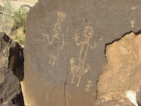
Along the Boca Negra Canyon trails, Ancestral Puebloans carved many different petroglyphs that date from between the 1300's to 1600's in what is called the Rio Grande style. We saw kokopellis, dancers, masks, animals, snakes, birds, human hands, stars, and spirals. Can you find these petroglyphs in the rocks below? We especially like the two dancers, one woman and one man, with the man dancing on what looks to be a chicken. We did see so many more great pictures; it was exciting to walk the trails and see each new image.


Something else that I thought was neat was basalt boulders that had these stripes in them. I read the plaque next to it that said that they formed when the rock cracked and later filled back in with new lava. It made me think of columnar jointing that occurs in basalts and wondered if it was related.


The views from the top of the mesa were really great. We were a mile above sea level overlooking the whole town of Albuquerque and Sandia Peak. The skies were a bit hazy, though, so things weren't too clear. At 10 am it was already 80 degrees. After our hike along the trails, we decided to do a little bit of geocaching and found 3 out of the 4 caches just north of the national monument, near the volcanoes. These are the three largest ones (right to left): Vulcan Volcano, Black Volcano, and JA Volcano. I hope to take another trip to explore them soon.
~~~~~~~~~
Neat