. . . I've been told that I write novels for email messages. Perhaps this is the way to go. I'll try to make each entry, or Gemstone, a "precious" one. On mediocre days, all I might be able to produce is a "semi-precious" entry. In any case, an entry might be a "neat" Gemstone--something that is uniquely mine.

Showing posts with label arizona. Show all posts

Thursday, April 10, 2014

Four Corners Monument

Four Corners Monument
To complete our southwestern spring break we took the back way home so that we could visit the Four Corners Monument. Of course, Four Corners is the only place where the four states of New Mexico, Arizona, Utah, and Colorado meet. The monument is on the Navajo Nation and is in the middle of absolute nowhere.

The original marker was erected in 1912 and was a simple cement pad, but now it is a whole circle of granite rock and brass. State flags surround the monument as well as four descriptions on when state lines were surveyed. It really is a nice monument and was a lot of fun to photograph ourselves on it.


Now you may have heard in recent years that the Monument is incorrectly placed by about 2.5 miles. That turned out not to be the case and was just an issue of interpreting survey lines of latitude and longitude from back in the days of drawing them (1860s). It turns out that the Monument is placed where it is supposed to be so no worries. 


Since the monument is on the Navajo Nation, vendors occupy all four “sides” of the monument in small cubbies with their beautiful jewelry and souvenirs. Be polite and browse--maybe even buy something.



On the way home we passed Shiprock, NM. Shiprock is a volcanic plug that has been exposed by the erosion of sedimentary layers to expose the hard volcanic rock. The highway was about 20 miles north of the formation that stood out in the middle of nowhere. The sacred formation figures prominently in Navajo Nation mythology as a giant bird that carried the Navajo from the cold northlands to the warm Four Corners region. 

Saturday, July 17, 2010

Petrified Forest National Park

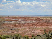
We took a detour off of I-40 as we headed east toward home yesterday and drove through Petrified Forest National Park and the Painted Desert. I've always driven straight through this stretch of Arizona but this time thought it'd be great to stop. Unfortunately, it was 100° outside so we didn't walk any long trails, preferring to drive to lookout points, getting out for pictures, and hurrying back into the air conditioned truck. Still, it was worth the extra time to go through.

Currently this portion of Arizona is a dry grasslands but about 200 million years ago during the late Triassic period it was a humid, tropical, vast floodplain that had many streams crossing it. Tall conifer trees grew along the banks would fall and the streams would wash them into the floodplains. A mix of silt, mud, and volcanic ash buried the logs. The sediment cut off oxygen and slowed the logs' decay. Over time silica-rich groundwater seeped through the logs, replacing the original wood tissues with silica deposits. Eventually the silica crystallized into quartz and the logs were preserved as petrified wood.

At the southern end of Petrified Forest National Park is a short Giant Logs Trail. Normally they say the 0.3 mile loop should take 20 minutes but I think we did it in 10 because of the heat. Still, we saw wonderful, colorful petrified wood deposits in the Chinle Formation. The colors of the logs are due to trace minerals that soaked into the wood along with the silica. Blue, purple, brown and black are caused by manganese minerals.

As you drive north along the park road you are driving toward younger deposits. At the farthest north, at Chinde Point on the Painted Desert portion of the park, the rocks are about 205 million years old. Over 10 million years of deposition occurred within the park. The views of the Painted Desert were remarkable. Next time I'd like to visit during the spring or fall when it isn't so hot!

Thursday, July 15, 2010

Sunset Crater Volcano National Monument

The third national monument we visited on Wednesday was located about 20 miles north of Flagstaff: the Sunset Crater Volcano National Monument. It is located within the San Francisco Volcanic Field on the Colorado Plateau that was active beginning six million years ago. Sunset Crater is the most recent eruption, exploding between 1040 and 1100. The Sinagua lived and farmed the area and so were witnesses to this eruption.

Sunset Crater is a cinder cone, forming when molten rock sprayed high into the air from a crack in the ground. The lava solidified and fell to Earth as large bombs or small cinders. Eruption after eruption occurred in this manner, building a debris pile up to 1,000 feet high. Two lava flows erupted near the vent, the Kana-a and the Bonito, and destroyed everything in their path. The entire event may have lasted 6 months to a year with a final eruption spewing red and yellow cinders out from the vent and onto the rim. The colorful glow from these cinders reminded people of a sunset and led to the volcano's name. The elevation at the summit is 8,029 feet with it's diameter at its base 1 mile. Approximately one billion tons of material was extruded from the vent.

We walked along a trail over the Bonito lava flow to the base of Sunset Crater. The gravel beneath our feet was black and the rocks a chunky, clinky form of lava called "aa." It is the same kind of lava flow that I walked over when on the big island of Hawaii. The rock is also known as "basalt."

The ancestors of today's Hopi people, the Sinagua, witnessed the eruption. In some Hopi accounts, the Qa'na Katsina caused Sunset Crater to erupt after people engaged in a life out of balance. The eruption is a living reminder that if people stray from their religious ideals and life, there may be another eruption.


Walnut Canyon National Monument

After we visited Meteor Crater yesterday, we went to Walnut Canyon National Monument near Flagstaff. At first all I saw as I walked the 270 steps down to the Island Trail from the visitor center were the rock layers. I noticed right away the cross bedding within the CoconinoSandstone (left) and the blocky pattern of the Kaibab Limestone that was above it. After looking more, I noticed ancient dwellings of the Sinagua built into one layer of the overhanging limestone cliffs.

In the canyon you see the layering of the Kaibab Limestone on top of the Coconino Sandstone but what you don't see right away is a limey shale layer under the limestone. Because shale is less resistant to weathering and erosion, it was carved away by flowing water, leaving the limestone overhang above it. The Sinagua built walls and fronts using the overhangs as roofs. They used blocks of limestone cemented with clay. The dwellings go back at least 10 feet and are on average 5 feet high.

The Sinagua lived in the canyon from 1125 to 1250 when the canyon was fertile. It is not clear why the people left but they moved to new villages and were eventually assimilated into the Hopi culture.

Meteor Crater

Yesterday (Wednesday) we visited another big hole in the ground, this one not formed from earth’s natural processes, but from something extraterrestrial.

Meteor crater was formed 50,000 years ago when an iron-nickel meteorite (meteors stay in the sky, meteorites hit the ground) struck what is now the Arizona desert. The meteor is estimated to have been about 150 feet across and weighed several hundred thousand tons (a 2-foot wide, 1,400-pound fragment of it is pictured, above left). It struck the land with an explosive force greater than 20 million tons of TNT. During the crater’s formation, over 175 million tons of rock were thrown out a distance of over a mile. Large blocks of limestone, the size of small houses, were heaved onto the rim and flat-lying beds of rock were overturned or uplifted as much as 150 feet.

The crater made a hole in the rocks of the Kaibab Limestone and Coconino Sandstone from 260 million years ago. The crater is over 4,000 feet across and 550 feet deep. Originally, the crater is thought to have been 700 feet deep (as tall as a 70-story building) but erosion has transferred the topsoil over time. The circumference is 2.4 miles.

How do scientists know that the crater isn’t a volcanic caldera? After all, people argued over its origin when it was first discovered in 1871. Local settlers just thought it was part of the Hopi Buttes volcanic field northeast of the site. After many years of study, scientists have concluded that it is definitely not volcanic and that it is the result of an impact. There is the presence of many meteorite fragments on the northeast side of the crater. Plus, two minerals: coesite and stishovite were present in the rocks, both high-pressure forms of quartz that were altered by the extremely high pressure of the impact. These minerals are not found in volcanic craters or rocks.

During 1964 through 1972, the US Geological Survey and NASA provided science and sampling training for the Apollo astronauts because scientists were interested in what kind of materials might lay on the moon’s surface and below.

Collisions have occurred since the beginning of the solar system and will continue to occur. Collisions the size of the one that hit Meteor Crater average every 50,000 years. It’s time for another one so luckily scientists are “looking” to the skies with their high-powered digital telescopes.

Some information came from what I learned from the museum displays and from a pamphlet handed out at the fee station called, “Meteor Crater: Brief History.”

Wednesday, July 14, 2010

The Grand Canyon in One Day

The Grand Canyon: "the place every American should see." — President Theodore Roosevelt

Yesterday we spent the whole day at the south rim of Grand Canyon National Park. As I mentioned in a previous blog entry, the last time I was at the Grand Canyon was 15 years ago but that time we only explored the east side of the south rim. I don’t remember whether we explored the west side of the south rim or not when I came here when I was 9, but in any case, we went al the way west to Hermit’s Rest and all the way east to Desert View this visit. We walked the rim trail as often as we could and took the shuttle bus when we didn’t.

Information on the Grand Canyon is all over the Internet and in many publications already so I won’t give an in-depth geologic history lesson here—just some basic facts.

The Grand Canyon cuts down into the Colorado Plateau that stretches north to Utah, northeast to Colorado, and east to New Mexico. At the south rim, the elevation is 7,000 feet. The Canyon spans almost 2 billion years of time from the basement rocks of the Vishnu Schist to the 270 million year old Kaibab Limestone at the top. Below the Kaibab Limestone is the same Coconino Sandstone and Hermit Shale exposed in the Sedona rocks.

According to the National Park Service pamphlet that is handed out at the entrance, “The Grand Canyon reveals a beautiful sequence of rock layers that serve as windows into time.” The Canyon was carved by the Colorado River 5 or 6 million years ago and is now about a mile deep. Its width varies from 8 miles to 18 miles wide and extends about 280 river miles long. As the river cuts down, the canyon deepens. Tributaries erode into the canyon’s sides and increase its width. Erosion carves faster into the softer rock layers like the shales and undermine the harder layers like the sandstones, creating cliffs, slopes, buttes, and pinnacles.

The views along the rim are inspiring and beautiful. Looking across the Canyon gives you such a feeling of power and beauty at the same time. What nature can create, with the dazzing erosional forms, rock colors, and geologic time is just awesome. Truly a place that every American, every person, should see.

Monday, July 12, 2010

The Verde Valley and Back to Sedona

This morning's adventure took us south of Sedona to the Verde Valley near the intersections of Hwy 179 and I-17. We explored Montezuma Castle National Monument and Montezuma Well. The area is within a fault zone and was once a freshwater lake 12 million years ago, forming a white limestone from the sediment. Scientists believe that faulting caused the lava dam holding in the water to fracture and the lake to drain 2 million years ago.

In a cave in the Verde Limestone, the Sinagua peoples built what is now called Montezuma Castle around 1150 CE. The structure is a 5-story, 20-room dwelling standing 100 feet above the valley. Early settlers believed the structure was Aztec in origin and named it "Montezuma" after the great Aztec emperor. The name has stuck. The Sinagua built this dwelling above Beaver Creek, which is now dry. Perhaps that was why the pueblo people left the area.

Eleven miles northeast of the castle is Montezuma Well, a limestone sink hole that formed by the collapse of an immense underground cavern about 11,000 years ago. There are still
springs that feed it so it remains full of water (a constant 76°) and there are species that live there that are not found anywhere else.

The Sinagua irrigated crops with the sink's water and built irrigation ditches to help them. There are cliff and cave dwellings and pueblo ruins to see along the trail. Stairs take you down 150 feet to the shoreline where there is a shady area with ruins. Another set of stairs down the trail takes you to a natural oasis where the 1,000-year-old irrigation ditch still flows today.

On the way back to Sedona, we stopped for two quick picture opportunities: Bell Rock and another view of Cathedral Rock. Since it was 93° outside, we didn't stay at either place very long, preferring to get back to the timeshare and the air conditioning and pool.

Tomorrow's Adventure: The Grand Canyon!!!

P.S. Bell Rock was another vortex location....nada!