I got to spend a couple of hours outdoors on a hike today. I always seem to forget that one way to release stress is to get out and go on a hike. I tend to just sit and suffer until I feel better. I take the hard way instead of doing something easy--taking a hike!
So today I tagged along with a group from my church (Unitarian Universalist) of middle school kids and a couple of their advisors. We set out to explore the
Quemazon Trail and find the Cave of the Winds. I've never been on this trail so was excited about setting out somewhere new. We parked at the little lot at the trailhead, walked along the trail, then turned left at the water tank to go up the hill. Some of the trail had us walking in ponderosa pines that had survived the fire but most of the trail was in the burn area. The view from different points along the way were beautiful. This photo on the above right is of our Omega Bridge, which connects our townsite to the Laboratory that is the major employer of our town. You can see the Sangre de Cristo mountains in the distance. Santa Fe is below the mountains in the valley toward the right.
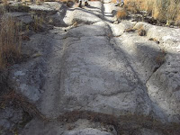
I found out that the Quemazon Trail used to be a main route from the Pajarito Plateau to the Valle Caldera and there were wagon ruts carved into the soft volcanic rock along the trail that we walked on. I could imagine the early homesteaders taking this route in their wagons and how difficult it must have been to go up and down the slope. I wonder how many days it took.
At the top of the first hill, we walked into the recovery area, and it was an area of such contrasts. There were broken off trees next to new ponderosa pines that were planted as seedlings the first years after the fire. I know a lot

of those seedlings didn't make it, but I was pleasantly surprised to see that there were quite a few around that looked healthy (reports say that 45% of seedlings have survived). There were grasses everywhere also, which were green a few months ago, but now are brown. Some purple asters and a few little berry bushes were also dotted around the area.
We found a trail marker off to the left of the trail that marked the way to the Cave of the Winds. Without that trail marker and someone who had been on the trail before, we would not have made the left turn! We walked a little way toward the canyon and at the edge, we headed down. The opening to the cave was about 50 feet down the hill and my knee felt every foot of it (damn patellar tendonitis!).

One by one, we went into the small opening and I was surprised that the cave opened up to a large space that was the size of my living room, maybe even bigger (left photo). There was an extra "room" off the back side of the cave that we discovered and once we got into that area, we turned off all our flashlights. It was completely dark! Flashlights did pop back on pretty quickly :-)).
After exploring the cave, we climbed out to sit on the rocks and
have some water and snacks. I was surprised again when looking across the canyon to the other side. The other side of the canyon was devastated by the fire while the hill that we were sitting on still had tall ponderosa pines scattered all over it.

I thought that this is what was meant when the news reporters said that the fire had "jumped the canyon" and was headed toward town. The fire just jumped over the slope we were on and burned the top of the hill.
The walk back didn't feel like it took as long as the walk up. I think it was a total of about 2 miles and just the right length for someone who hasn't hiked in a while. The weather was beautiful, the company was pleasant, and the kids didn't complain at all. It was a fun expedition and I can't wait until the next time I can go out hiking.
~~~~~~~~~
Neat





 Yesterday evening, six of us went out on a hike before going out to our monthly "Ladies Night Out" dinner. We decided to go on Deer Trap Mesa (beginning of trail on left photo), which was a
 challenge at first because of so many rocks to climb straight up or down before getting to the actual flat mesa top trail, which is high above Barranca canyon on the right. I found the stair pathways up and down the rocks fascinating because of the foot marks ground into the soft tuff rock (photo, above right). I imagined the Ancestral Pueblo Indians carving those steps as they walked the route every day.
  Another fascinating structure was the "Deer Trap" that was roughly a 6 x 8 foot rectangle at around 5 foot deep (photo, left). I imagine that the Pueblo people would cover the trap with grasses or twigs and wait for an animal such as a deer to walk over it and drop into the trap, unable to get out and becoming the meal of the day. After walking on top of the rocks
 for a while, the mesa top does widen out and a really nice trail takes you to the end. At the end of the trail is a lovely view of the mesas around Los Alamos, the Rio Grande Valley, and the Sangre de Cristo Mountains beyond (photo, above right). The round trip was just under 3 miles and took us a bit over an hour.
 One of my favorite things to do is to explore new places, especially if they include an outdoor adventure. My family was able to take the Sandia Peak Tramway in Albuquerque yesterday and explored the top of the mountain. It was kind of a spontaneous event since we originally were in Albuquerque to attend the annual Balloon Fiesta but the balloons never made it off the ground for the mass ascension due to high winds. So we thought we'd do something else in Albuquerque that day. We've lived in New Mexico for 10 years now and hadn't attended Balloon Fiesta or gone on the Tramway.
 Of course, there's a lot of geology that I learned on this trip, which makes the adventure even better! The Sandia Mountains are a fault-block range on the eastern edge of the Rio Grande Rift Valley. The base of the tram is at about 6,500 feet elevation and is situated on a bedrock of Sandia Granite (photo, above right). The granite formed underground about 1.4 billion years ago, cooling slowly to give large crystals and phenocrysts throughout. It is rich in mica, potassium feldspar, and quartz. The feldspar is a pinkish color so the mountain actually "glows" pink at sunset. It's beautiful, for sure. I learned that "Sandia" means "watermelon" in Spanish, so the pink mountain is like the inside of the watermelon and the green conifer trees at the top of the mountain are like the green rind. And of course, watermelons are pinkish.
 On the very top of the Sandia Granite is a cap of limestone that formed about 250 million years ago when the whole area was covered by an inland sea. So the granite basement rock had


 Yesterday I hiked up the Mitchell Trail here in my town and today my thighs are still sore from that 1,000 foot climb up from the bottom. Every time I got up out of a chair, my thighs would burn and it would remind me of the great hike (great because the run down the mountain was a blast and I had two friends with me) and made me wonder where the trail got its name. So today, I did what I always do when I have a question and want an answer: I Googled it!

 Last summer an old college friend took a detour to our home while on a summer trip from her home out to California. She and her kids introduced my oldest son to geocaching, which according to the geocaching.com website is:


 Posts
Posts


