So today I tagged along with a group from my church (Unitarian Universalist) of middle school kids and a couple of their advisors. We set out to explore the Quemazon Trail and find the Cave of the Winds. I've never been on this trail so was excited about setting out somewhere new. We parked at the little lot at the trailhead, walked along the trail, then turned left at the water tank to go up the hill. Some of the trail had us walking in ponderosa pines that had survived the fire but most of the trail was in the burn area. The view from different points along the way were beautiful. This photo on the above right is of our Omega Bridge, which connects our townsite to the Laboratory that is the major employer of our town. You can see the Sangre de Cristo mountains in the distance. Santa Fe is below the mountains in the valley toward the right.

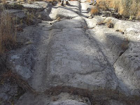
I found out that the Quemazon Trail used to be a main route from the Pajarito Plateau to the Valle Caldera and there were wagon ruts carved into the soft volcanic rock along the trail that we walked on. I could imagine the early homesteaders taking this route in their wagons and how difficult it must have been to go up and down the slope. I wonder how many days it took.
At the top of the first hill, we walked into the recovery area, and it was an area of such contrasts. There were broken off trees next to new ponderosa pines that were planted as seedlings the first years after the fire. I know a lot
 of those seedlings didn't make it, but I was pleasantly surprised to see that there were quite a few around that looked healthy (reports say that 45% of seedlings have survived). There were grasses everywhere also, which were green a few months ago, but now are brown. Some purple asters and a few little berry bushes were also dotted around the area.
We found a trail marker off to the left of the trail that marked the way to the Cave of the Winds. Without that trail marker and someone who had been on the trail before, we would not have made the left turn! We walked a little way toward the canyon and at the edge, we headed down. The opening to the cave was about 50 feet down the hill and my knee felt every foot of it (damn patellar tendonitis!).

One by one, we went into the small opening and I was surprised that the cave opened up to a large space that was the size of my living room, maybe even bigger (left photo). There was an extra "room" off the back side of the cave that we discovered and once we got into that area, we turned off all our flashlights. It was completely dark! Flashlights did pop back on pretty quickly :-)).
After exploring the cave, we climbed out to sit on the rocks and
have some water and snacks. I was surprised again when looking across the canyon to the other side. The other side of the canyon was devastated by the fire while the hill that we were sitting on still had tall ponderosa pines scattered all over it.
 I thought that this is what was meant when the news reporters said that the fire had "jumped the canyon" and was headed toward town. The fire just jumped over the slope we were on and burned the top of the hill.
The walk back didn't feel like it took as long as the walk up. I think it was a total of about 2 miles and just the right length for someone who hasn't hiked in a while. The weather was beautiful, the company was pleasant, and the kids didn't complain at all. It was a fun expedition and I can't wait until the next time I can go out hiking.
~~~~~~~~~
Neat
Neat


2 comments:
Glad you enjoyed getting out and hiking as you have always done. Pictures were wonderful. Happy to see the trees are filling in. Question. I noticed on your blog that when I move the curser over a picture and double click to enlarge the picture, it doesn't do so. Other Blogs I have looked at do enlarge the picture. Your might want to take a look it it.
Mom
Hmmmm. That is a mystery. I looked at all the pictures in this post and no, they don't open up to a larger one. Other post's pictures do like the pumpkin and vampire photos. I have no idea why this happened.
Post a Comment